
Preface
![]() The narrative which follows
is taken in part from the field journal for my 1989 field season. I will
refer to a few events which occurred in the 1990 field season as well. These
events took place mostly in the Shumigan Islands near the tip of the Alaska
Peninsula while I was employed as a precious metals exploration geologist
with Battle Mountain Gold Corporation. One of the earthquakes I shall refer
to occurred in 1990 in the central Aleutians while I was prospecting
Unalaska and Umnak Islands for Battle Mountain Gold Corporation.
The narrative which follows
is taken in part from the field journal for my 1989 field season. I will
refer to a few events which occurred in the 1990 field season as well. These
events took place mostly in the Shumigan Islands near the tip of the Alaska
Peninsula while I was employed as a precious metals exploration geologist
with Battle Mountain Gold Corporation. One of the earthquakes I shall refer
to occurred in 1990 in the central Aleutians while I was prospecting
Unalaska and Umnak Islands for Battle Mountain Gold Corporation.
![]() Although, how I came to be in
this location is a story in itself, I will reserve that for a future time.
On Sunday, June 4, 1989, I found myself part of a hand picked team of geologists
walking beneath the 200' to 500' high beach cliffs of Popof Island, as Bill Ellis,
the head of our field operations, gave us an exhaustive introduction to the
geology we would soon be prospecting for gold. Our helicopter was flying
the long semicircle around the Gulf of Alaska from Seattle and would not
arrive for another week, so we had lots of time for sightseeing. We were in a
spectacular place of high snow capped peaks, and deep and impossibly violent
ocean passages cutting into, or through, the islands.
Although, how I came to be in
this location is a story in itself, I will reserve that for a future time.
On Sunday, June 4, 1989, I found myself part of a hand picked team of geologists
walking beneath the 200' to 500' high beach cliffs of Popof Island, as Bill Ellis,
the head of our field operations, gave us an exhaustive introduction to the
geology we would soon be prospecting for gold. Our helicopter was flying
the long semicircle around the Gulf of Alaska from Seattle and would not
arrive for another week, so we had lots of time for sightseeing. We were in a
spectacular place of high snow capped peaks, and deep and impossibly violent
ocean passages cutting into, or through, the islands.
![]() Bill impressed us all when he
rolled over one of the beach cobbles and picked up several small gold nuggets
lying glittering in the all too rare sunlight. He told us not to get
too excited because the beach placer was already owned, and the owner wanted to
sell it to us for $3,000,000! We did have the owner's permission to collect as much gold
as we wanted in our "free" time. Since we worked 30 days on and 1 day off,
we would not be getting rich at the placer.
Bill impressed us all when he
rolled over one of the beach cobbles and picked up several small gold nuggets
lying glittering in the all too rare sunlight. He told us not to get
too excited because the beach placer was already owned, and the owner wanted to
sell it to us for $3,000,000! We did have the owner's permission to collect as much gold
as we wanted in our "free" time. Since we worked 30 days on and 1 day off,
we would not be getting rich at the placer.
![]() I did not know it yet, but I
was about to start one of the most physically demanding experiences of my
life. That is saying a lot, considering I had previously had a remarkable experience
while spending 30 days at sea skippering a 36 foot yacht between the Grenadine
Islands and Florida. During this period we fought through hurricane Alice, while
suffering little sleep and almost no food. I lost over 30 pounds in that short time
period! Little did I know that similar physical hardships were just around
the corner. The big difference, however, was that we had unlimited food of
the highest quality. Even with the wonderful dining I would soon trim down
by more than twenty pounds.
I did not know it yet, but I
was about to start one of the most physically demanding experiences of my
life. That is saying a lot, considering I had previously had a remarkable experience
while spending 30 days at sea skippering a 36 foot yacht between the Grenadine
Islands and Florida. During this period we fought through hurricane Alice, while
suffering little sleep and almost no food. I lost over 30 pounds in that short time
period! Little did I know that similar physical hardships were just around
the corner. The big difference, however, was that we had unlimited food of
the highest quality. Even with the wonderful dining I would soon trim down
by more than twenty pounds.
![]() Being the only civil
engineer/geologist, I was soon assigned the job of designing and
flagging
a three mile access road to the top of our first prospect, "Propolof."
With
one evening of design and layout time behind me, I found myself 100
yards ahead of a D-8 Cat, Brunton compass in one hand and flagging in
the other,
laying out the horribly steep and winding road up the mountain. This
road led to the top
of a high peak where a strange crater-like formation lay hidden. I
managed
to stay just ahead of the dozer and finished the road layout by early
evening.
I stopped at the top for a rest and to gaze upon the fantastic beauty
of
the ocean and islands stretching off into the distance. I also looked
closely
at the strange crater lying just below me.
Being the only civil
engineer/geologist, I was soon assigned the job of designing and
flagging
a three mile access road to the top of our first prospect, "Propolof."
With
one evening of design and layout time behind me, I found myself 100
yards ahead of a D-8 Cat, Brunton compass in one hand and flagging in
the other,
laying out the horribly steep and winding road up the mountain. This
road led to the top
of a high peak where a strange crater-like formation lay hidden. I
managed
to stay just ahead of the dozer and finished the road layout by early
evening.
I stopped at the top for a rest and to gaze upon the fantastic beauty
of
the ocean and islands stretching off into the distance. I also looked
closely
at the strange crater lying just below me.
![]() The "crater," as we all called
it, was about half a mile wide. It had numerous small lakes in the bottom,
and showed patches of brightly colored hydrothermally altered rock in places.
What was stranger still were a series of sub parallel lines cutting across
the crater. Some of the lines joined neighboring lines, forming an intricate pattern in the tundra. I probably would not have
even noticed most of them except that the sun was low, and the oblique lighting
showed them up quite distinctly. Less than a week later a similar lighting
situation would give me the clues that would soon allow me to unlock the
mystery of the "crater." I did notice that several of the lines were deeply
cut into the tundra, much as if a plow had cut one single giant furrow
across the crater. In places there were big blocks of tundra standing on
edge as much as three feet above the surrounding surface along the furrow, which was three to four feet deep in places!
The "crater," as we all called
it, was about half a mile wide. It had numerous small lakes in the bottom,
and showed patches of brightly colored hydrothermally altered rock in places.
What was stranger still were a series of sub parallel lines cutting across
the crater. Some of the lines joined neighboring lines, forming an intricate pattern in the tundra. I probably would not have
even noticed most of them except that the sun was low, and the oblique lighting
showed them up quite distinctly. Less than a week later a similar lighting
situation would give me the clues that would soon allow me to unlock the
mystery of the "crater." I did notice that several of the lines were deeply
cut into the tundra, much as if a plow had cut one single giant furrow
across the crater. In places there were big blocks of tundra standing on
edge as much as three feet above the surrounding surface along the furrow, which was three to four feet deep in places!
![]() I found the view of the tortured tundra strangely
disquieting. Looking at the crater I got a cold chill down my neck, and my
hair wanted to stand on end. I passed it off as a side effect of being all
alone, looking at the fantastic view, and starting to chill due to the 40-50
mph winds cutting across the peak. It was apparent that the good weather
was about to end, as I watched the islands disappear in the rapidly forming
fog and clouds. I would soon get to know that weather pattern very well as the unending
storms lashed our little tent camp. I would also almost forget what sunlight was
as the only four sunny days of the season passed into memory. I didn't know
it yet, but my next field season the following year would be much better, with a full 6 days
of sun shine!
I found the view of the tortured tundra strangely
disquieting. Looking at the crater I got a cold chill down my neck, and my
hair wanted to stand on end. I passed it off as a side effect of being all
alone, looking at the fantastic view, and starting to chill due to the 40-50
mph winds cutting across the peak. It was apparent that the good weather
was about to end, as I watched the islands disappear in the rapidly forming
fog and clouds. I would soon get to know that weather pattern very well as the unending
storms lashed our little tent camp. I would also almost forget what sunlight was
as the only four sunny days of the season passed into memory. I didn't know
it yet, but my next field season the following year would be much better, with a full 6 days
of sun shine!
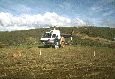
![]() A week later our helicopter
arrived. The craft was a beauty, an Alouette A-Star.
It could carry four in the back seat, and a cramped three in the front. Everyone
was pretty excited as it settled on the pad for the first time. Our camp
mascot "Diamond," a beautiful golden Lab, quickly adopted the aircraft as
his own. The helicopter could not take off without Diamond on board, lying at
the pilot's feet.
A week later our helicopter
arrived. The craft was a beauty, an Alouette A-Star.
It could carry four in the back seat, and a cramped three in the front. Everyone
was pretty excited as it settled on the pad for the first time. Our camp
mascot "Diamond," a beautiful golden Lab, quickly adopted the aircraft as
his own. The helicopter could not take off without Diamond on board, lying at
the pilot's feet.
![]() The next morning Bill assembled
all members of the camp, exploration geologists, camp based rock sample
testing and logging geologists, cooks, and camp manager, to organize an all
day helicopter tour of the islands and the sites we would be working. Since
the crew was too big to all go on one trip, we employed a leap frog process,
with the exploration crew going first, and the rest of the crew following
on the next trip. It was just after sunrise when I climbed on board for my
first ride in the A-Star. We lifted off in a buzz of excited chatter between the members of the exploration crew.
The next morning Bill assembled
all members of the camp, exploration geologists, camp based rock sample
testing and logging geologists, cooks, and camp manager, to organize an all
day helicopter tour of the islands and the sites we would be working. Since
the crew was too big to all go on one trip, we employed a leap frog process,
with the exploration crew going first, and the rest of the crew following
on the next trip. It was just after sunrise when I climbed on board for my
first ride in the A-Star. We lifted off in a buzz of excited chatter between the members of the exploration crew.
![]() The next five minutes proved
to be the most important I would experience during my two seasons in the
Aleutians. I had a window seat, and my intense interest in the islands kept
me glued to the window. Everyone else was too preoccupied in their conversation
to really look closely at the ground below us. In the oblique early morning light
I could distinctly see a network of sub parallel lines
cutting
across the islands, very similar to those I had seen a week earlier in
the
crater. They became invisible when the Sun rose higher and the light
became more direct. At this point neither instance made a great
impression on me, but
the lines were now filed away in my mind ready for events yet to come.
The next five minutes proved
to be the most important I would experience during my two seasons in the
Aleutians. I had a window seat, and my intense interest in the islands kept
me glued to the window. Everyone else was too preoccupied in their conversation
to really look closely at the ground below us. In the oblique early morning light
I could distinctly see a network of sub parallel lines
cutting
across the islands, very similar to those I had seen a week earlier in
the
crater. They became invisible when the Sun rose higher and the light
became more direct. At this point neither instance made a great
impression on me, but
the lines were now filed away in my mind ready for events yet to come.
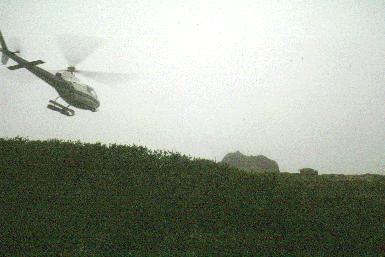
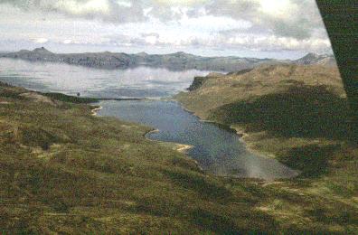
![]() We had a wonderful day, covering
many miles and many islands. The helicopter had to make frequent refueling
trips back to camp while we explored the various locations.
We landed on mountain tops, tundra, beaches, and even made
our first "single skid" landing, a technique that would soon be one of
our most common landing methods in rough terrain. During this first flight
we even passed closely over a large herd of wild buffalo, or bison, that
were left behind from a failed ranch on Popof Island. The buffalo had taken
over the island and were living happily there by the hundreds. Two weeks
later I would have a very close encounter with a huge bull
buffalo. (In the image, the bump to the right of the big rock is the
buffalo being chased away by the helicopter.) It still gives me chills when
I think about it. Only the fast action of our pilot, Jim, averted catastrophe
for me. He would prove equally reliable later in the season when we started
working close to the giant brown bears of the Alaska Peninsula.
We had a wonderful day, covering
many miles and many islands. The helicopter had to make frequent refueling
trips back to camp while we explored the various locations.
We landed on mountain tops, tundra, beaches, and even made
our first "single skid" landing, a technique that would soon be one of
our most common landing methods in rough terrain. During this first flight
we even passed closely over a large herd of wild buffalo, or bison, that
were left behind from a failed ranch on Popof Island. The buffalo had taken
over the island and were living happily there by the hundreds. Two weeks
later I would have a very close encounter with a huge bull
buffalo. (In the image, the bump to the right of the big rock is the
buffalo being chased away by the helicopter.) It still gives me chills when
I think about it. Only the fast action of our pilot, Jim, averted catastrophe
for me. He would prove equally reliable later in the season when we started
working close to the giant brown bears of the Alaska Peninsula.
![]() Our view of the southern Alaska
Peninsula to the west was dominated by
Pavlof
volcano. When the weather was clear it was a spectacular sight. The weather
closed in for an extended period, and when it broke for a few hours we could
see that the volcano had been in eruption. All the snow was covered with
black ash. It erupted several more times during the summer, but we never
got to see it happen. It was always in the clouds during the eruptive events.
Later, toward the end of the season, we would be working right near the base
of the smoking giant.
Our view of the southern Alaska
Peninsula to the west was dominated by
Pavlof
volcano. When the weather was clear it was a spectacular sight. The weather
closed in for an extended period, and when it broke for a few hours we could
see that the volcano had been in eruption. All the snow was covered with
black ash. It erupted several more times during the summer, but we never
got to see it happen. It was always in the clouds during the eruptive events.
Later, toward the end of the season, we would be working right near the base
of the smoking giant.
![]() On Tuesday, July 18,
I made
the most significant geologic observation of my career. I had to lay
out
sample lines up and over the top of Propolof prospect. It required
surveying
down through the crater area. I had a young college student, Dennis, along as my
helper
when I sat down on a hill within the crater for lunch. As we sat there
talking
I kept studying the strange pattern of sub parallel lines crossing the crater floor. The more I
looked,
the more certain I was that I was looking at an incredible series of
fault lines.
It was a classic imbricate fault structure! The more I looked the more
excited
I became. Several of the lines, as I mentioned earlier, were very
deeply
cut. In fact they were ragged trenches with the tundra ripped up into
large
blocks that were tilted up on edge at various angles. As I realized
what
I was looking at my hair began to stand on end once more. Later I walked
down into
one of the trenches, and it was waist deep and three to four feet wide.
It
cut down into the "crater," across the bottom, and back up and out the
other
side. These were freshly torn open fault lines, the cause of recent earthquakes. The fact that both
sides
were the same elevation indicated it was a strike slip fault. What I
needed
to know was if it was a left or right lateral strike slip fault,
meaning,
when I looked at the other side of the fault, had it moved to the right
or
left? The subsequent erosion of the ripped up blocks of tundra
prevented me from determining the fault motion by the orientation of
the blocks with any degree of certainty, and I needed to be absolutely
correct.
On Tuesday, July 18,
I made
the most significant geologic observation of my career. I had to lay
out
sample lines up and over the top of Propolof prospect. It required
surveying
down through the crater area. I had a young college student, Dennis, along as my
helper
when I sat down on a hill within the crater for lunch. As we sat there
talking
I kept studying the strange pattern of sub parallel lines crossing the crater floor. The more I
looked,
the more certain I was that I was looking at an incredible series of
fault lines.
It was a classic imbricate fault structure! The more I looked the more
excited
I became. Several of the lines, as I mentioned earlier, were very
deeply
cut. In fact they were ragged trenches with the tundra ripped up into
large
blocks that were tilted up on edge at various angles. As I realized
what
I was looking at my hair began to stand on end once more. Later I walked
down into
one of the trenches, and it was waist deep and three to four feet wide.
It
cut down into the "crater," across the bottom, and back up and out the
other
side. These were freshly torn open fault lines, the cause of recent earthquakes. The fact that both
sides
were the same elevation indicated it was a strike slip fault. What I
needed
to know was if it was a left or right lateral strike slip fault,
meaning,
when I looked at the other side of the fault, had it moved to the right
or
left? The subsequent erosion of the ripped up blocks of tundra
prevented me from determining the fault motion by the orientation of
the blocks with any degree of certainty, and I needed to be absolutely
correct.
![]() The reason this was important
is because the gold deposit on Propolof was truncated. It stopped abruptly.
Knowing the motion of the faults might tell me where the other part of the
deposit had gone. All of this came to me in a rush as we explored the crater.
The parallel lines I had seen from the helicopter during that first flight,
the lines cutting through the crater, all fit the picture. In my mind's eye I was now
seeing the island made up of a large collection of faults and fault slices. I would
later be able to determine that the faults were spaced at the incredibly small
spacing of only 50-150 feet in many places!
The reason this was important
is because the gold deposit on Propolof was truncated. It stopped abruptly.
Knowing the motion of the faults might tell me where the other part of the
deposit had gone. All of this came to me in a rush as we explored the crater.
The parallel lines I had seen from the helicopter during that first flight,
the lines cutting through the crater, all fit the picture. In my mind's eye I was now
seeing the island made up of a large collection of faults and fault slices. I would
later be able to determine that the faults were spaced at the incredibly small
spacing of only 50-150 feet in many places!
![]() We spent the afternoon studying
the crater which overlooked Red Cove,
and luck was with
me. On one side the crater was open where a fault cut across it, forming
a
cliff which dropped into a deep valley below. I was able to climb down
the
cliff, and the "slickensides" left on the hard basalt cliff face due to the fault movement told
the
story. There were tension cracks, drag cracks, that told me the fault
was
a right lateral strike slip fault. That means that if you stand with one foot on
each
side of the fault, the block on your right side would be moving toward
you during an earthquake. By this time I was boiling over with
excitement.
We spent the afternoon studying
the crater which overlooked Red Cove,
and luck was with
me. On one side the crater was open where a fault cut across it, forming
a
cliff which dropped into a deep valley below. I was able to climb down
the
cliff, and the "slickensides" left on the hard basalt cliff face due to the fault movement told
the
story. There were tension cracks, drag cracks, that told me the fault
was
a right lateral strike slip fault. That means that if you stand with one foot on
each
side of the fault, the block on your right side would be moving toward
you during an earthquake. By this time I was boiling over with
excitement.
![]() The reason for my excitement
was that this was the third year of a five year project. The crater, and
its ore deposit, had been discovered some time earlier. The problem was that
the ore body stopped suddenly, and no one knew where it went or why it stopped.
A large number of very high powered geologists had worked on the problem
without sucess. It was only that early morning flight that had made the
difference for me. I now had the key to unlock the secret of the crater.
The reason for my excitement
was that this was the third year of a five year project. The crater, and
its ore deposit, had been discovered some time earlier. The problem was that
the ore body stopped suddenly, and no one knew where it went or why it stopped.
A large number of very high powered geologists had worked on the problem
without sucess. It was only that early morning flight that had made the
difference for me. I now had the key to unlock the secret of the crater.
![]() I told Dennis to say nothing
about the discovery. I spent the remaining few hours field mapping the biggest
faults. As I worked, it all became very clear what was going on. The crater
was a huge fault sag and not a crater at all. The chemical alteration of the rocks
was due to hydrothermal fluids coming up the faults, this was a classic process
of mineralization on a large scale.
I told Dennis to say nothing
about the discovery. I spent the remaining few hours field mapping the biggest
faults. As I worked, it all became very clear what was going on. The crater
was a huge fault sag and not a crater at all. The chemical alteration of the rocks
was due to hydrothermal fluids coming up the faults, this was a classic process
of mineralization on a large scale.
![]() After the chopper
picked us up
and returned us to camp I had a hard time containing my excitement. I
didn't
want to release it yet however, because I wanted a little more time to
get
the majority of the area geologically mapped. Unfortunately Dennis
couldn't restrain
himself and he made a comment to Bill, our camp boss. Bill came right
to
me and took me aside asking me to explain what I had discovered. I told
him
what I had observed, and that I had determined it was a right lateral
imbricate
fault system of giant proportions. He said not to talk about it, and asked
me to fly up the next day and completely map the crater. He was keeping it
quiet because
each geologist had been given certain areas of responsibility to
geologically map, and this area was not mine. It had been mapped by two
senior level geologists
who had not mapped a single fault there. When I brought this new
information to light there
was going to be raw feelings in camp.
After the chopper
picked us up
and returned us to camp I had a hard time containing my excitement. I
didn't
want to release it yet however, because I wanted a little more time to
get
the majority of the area geologically mapped. Unfortunately Dennis
couldn't restrain
himself and he made a comment to Bill, our camp boss. Bill came right
to
me and took me aside asking me to explain what I had discovered. I told
him
what I had observed, and that I had determined it was a right lateral
imbricate
fault system of giant proportions. He said not to talk about it, and asked
me to fly up the next day and completely map the crater. He was keeping it
quiet because
each geologist had been given certain areas of responsibility to
geologically map, and this area was not mine. It had been mapped by two
senior level geologists
who had not mapped a single fault there. When I brought this new
information to light there
was going to be raw feelings in camp.
![]() There was another event that
had occurred that same day that I was not yet aware of. Bill had met with a woman
geologist in Sand Point that morning. She was concluding a 10 year study
of the tectonics of the Shumigan islands. She had told Bill that the islands were
cut by an imbricate series of right lateral faults! When I said the same
thing, Bill became as excited as I was, but didn't let on to me. He instantly
realized the significance of this information.
There was another event that
had occurred that same day that I was not yet aware of. Bill had met with a woman
geologist in Sand Point that morning. She was concluding a 10 year study
of the tectonics of the Shumigan islands. She had told Bill that the islands were
cut by an imbricate series of right lateral faults! When I said the same
thing, Bill became as excited as I was, but didn't let on to me. He instantly
realized the significance of this information.
![]() Once a week we would stay in
camp for a geology "round table meeting" to discuss the weeks findings. On
Friday, July 21, we met during one of the typical Aleutian storms. With the
wind hitting 80+ mph, and the rain coming down in torrents, we tried to discuss
our work. The first thing on the agenda was the crater on Propolof. Bill asked me to relate
what I had found. I had not even finished before the two geologists whose
area I was discussing violently disagreed with me. After all, they were
full time year round geologists, not a summer contract geologist like me.
After several hours of very heated discussion and argument, Bill settled
the issue by announcing that he was having a geophysical exploration company
send in two men with their "magic black boxes" to do a study of the crater
area. Using low frequency resonance, and magnetic detection equipment, the
issue would soon be resolved by their findings. I had a lot riding on what they found.
Once a week we would stay in
camp for a geology "round table meeting" to discuss the weeks findings. On
Friday, July 21, we met during one of the typical Aleutian storms. With the
wind hitting 80+ mph, and the rain coming down in torrents, we tried to discuss
our work. The first thing on the agenda was the crater on Propolof. Bill asked me to relate
what I had found. I had not even finished before the two geologists whose
area I was discussing violently disagreed with me. After all, they were
full time year round geologists, not a summer contract geologist like me.
After several hours of very heated discussion and argument, Bill settled
the issue by announcing that he was having a geophysical exploration company
send in two men with their "magic black boxes" to do a study of the crater
area. Using low frequency resonance, and magnetic detection equipment, the
issue would soon be resolved by their findings. I had a lot riding on what they found.
![]() For the next two weeks, while the geophysicists did their work in the crater, the tension
in camp was so thick you could have cut it with a knife. Finally the day
was at hand. We all met in the office tent for our round table meeting, along
with two new members from the geophysics company. I was asked to lay out
my geologic field map of the crater area. Then the "geowizzes," as they are commonly called, were asked
to present their findings. At this point my heart was beating like a trip
hammer.
For the next two weeks, while the geophysicists did their work in the crater, the tension
in camp was so thick you could have cut it with a knife. Finally the day
was at hand. We all met in the office tent for our round table meeting, along
with two new members from the geophysics company. I was asked to lay out
my geologic field map of the crater area. Then the "geowizzes," as they are commonly called, were asked
to present their findings. At this point my heart was beating like a trip
hammer.
![]() As their report was presented, their field
map was almost an exact duplicate of mine! My faults exactly matched their's
in the crater. They had a few additional faults, "structures," outside the
crater where the surface evidence did not allow me to detect them. I had
carried the day, but the anger that it created was to persist the rest of
the season. We never were able to find the missing slice of the ore deposit.
We were able, however, to determine that the faulting had displaced the ore body many
miles northward. We searched the islands to the north, but finally gave up, concluding
that it had either been concealed below the surface of the ground or was presently beneath
the sea between the islands. Because of that missing slice, the ore deposit
was not large enough to be economic to mine.
As their report was presented, their field
map was almost an exact duplicate of mine! My faults exactly matched their's
in the crater. They had a few additional faults, "structures," outside the
crater where the surface evidence did not allow me to detect them. I had
carried the day, but the anger that it created was to persist the rest of
the season. We never were able to find the missing slice of the ore deposit.
We were able, however, to determine that the faulting had displaced the ore body many
miles northward. We searched the islands to the north, but finally gave up, concluding
that it had either been concealed below the surface of the ground or was presently beneath
the sea between the islands. Because of that missing slice, the ore deposit
was not large enough to be economic to mine.
![]() I was to run into the ripped
tundra in other locations a number of times that first season, and again
a thousand miles farther out in the Aleutian chain during my second season. In each case it was
from a very recent earthquake, probably in the last 5 years or less. I experienced
many earthquakes there, including two of substantial size. During one of them in Dutch Harbor I was
awakened at 2:00 AM,
and sent racing
up a nearby hill side by the local fire department with my gear under
my arm. They
went racing through Dutch Harbor with their siren screaming, telling everyone to
head
for high ground due to a tidal wave, "tsunami," warning. I took this
warning
very seriously, having almost lost my life in the huge tsunami that hit
Okinawa
in 1962 from the great Chile earthquake. I was chagrined to observe
that many
of the sailors in Dutch Harbor headed up the hill sides with a case of
beer under
each arm! I guess they had their priorities too. One of the most
spectacular indications of the very active tectonics I saw in the Aleutians was
a bay on the Alaska Peninsula
with 20-30 stranded beaches, one above the other. Each beach
represented
a great earthquake and a sudden uplift of the land of 20-30 feet!
I was to run into the ripped
tundra in other locations a number of times that first season, and again
a thousand miles farther out in the Aleutian chain during my second season. In each case it was
from a very recent earthquake, probably in the last 5 years or less. I experienced
many earthquakes there, including two of substantial size. During one of them in Dutch Harbor I was
awakened at 2:00 AM,
and sent racing
up a nearby hill side by the local fire department with my gear under
my arm. They
went racing through Dutch Harbor with their siren screaming, telling everyone to
head
for high ground due to a tidal wave, "tsunami," warning. I took this
warning
very seriously, having almost lost my life in the huge tsunami that hit
Okinawa
in 1962 from the great Chile earthquake. I was chagrined to observe
that many
of the sailors in Dutch Harbor headed up the hill sides with a case of
beer under
each arm! I guess they had their priorities too. One of the most
spectacular indications of the very active tectonics I saw in the Aleutians was
a bay on the Alaska Peninsula
with 20-30 stranded beaches, one above the other. Each beach
represented
a great earthquake and a sudden uplift of the land of 20-30 feet!
![]() We now have some amazing information regarding the tsunamis in the
Aleutians and Gulf of Alaska. In the
Aleutians, evidence has been found of a wave reaching a height in excess
of 3000 feet! Also, in SE Alaska, in Lituya Bay in 1954, an earthquake occurred
that created a giant wave which swept down the bay, clearing all soil and
timber off the hill sides to an elevation in excess of 1700 feet! There were
a number of fishing boats in the bay at the time. One of the boats survived
after being carried over a peninsula covered with forest, and being deposited
in the sea. The husband and wife team abandoned their sinking craft and climbed into a
small dingy and lived to tell the tale. The local Indians had long told stories
of great waves in the bay, but no one believed them until this happened. Now
we know that great waves are a regular occurrence in Lituya Bay, caused by earthquakes on the Fairweather
Fault which cuts through the upper bay.
We now have some amazing information regarding the tsunamis in the
Aleutians and Gulf of Alaska. In the
Aleutians, evidence has been found of a wave reaching a height in excess
of 3000 feet! Also, in SE Alaska, in Lituya Bay in 1954, an earthquake occurred
that created a giant wave which swept down the bay, clearing all soil and
timber off the hill sides to an elevation in excess of 1700 feet! There were
a number of fishing boats in the bay at the time. One of the boats survived
after being carried over a peninsula covered with forest, and being deposited
in the sea. The husband and wife team abandoned their sinking craft and climbed into a
small dingy and lived to tell the tale. The local Indians had long told stories
of great waves in the bay, but no one believed them until this happened. Now
we know that great waves are a regular occurrence in Lituya Bay, caused by earthquakes on the Fairweather
Fault which cuts through the upper bay.

![]() I hope you enjoyed this narrative. I also hope
that you can get to the Aleutians someday to see the amazing landscape of these spactacular islands. If
you go, take your rain gear, gum boots, and if you plan to camp in the islands
near the Alaska Peninsula, bring a BIG gun. We observed 22 big brownies in
15 minutes from our helicopter in that area!
I hope you enjoyed this narrative. I also hope
that you can get to the Aleutians someday to see the amazing landscape of these spactacular islands. If
you go, take your rain gear, gum boots, and if you plan to camp in the islands
near the Alaska Peninsula, bring a BIG gun. We observed 22 big brownies in
15 minutes from our helicopter in that area!
27 Mar 00
©Golden Age Forge
![]()
![]()
![]()